Indian Ocean
Updated
Area
70,560,000 km²
CIA World Factbook archive
Location
- Region
- Oceans
- Area
- 70,560,000 km²
The Factbook archive 18 fields · 4 categories
The complete World Factbook entry for Indian Ocean: 18 fields and 15 sub-entries across 4 categories, kept whole as historical reference. A United States Government work in the public domain, reflecting data as of the final January 2026 edition. Last CIA update: January 12, 2026.
Introduction 1 field
- Background
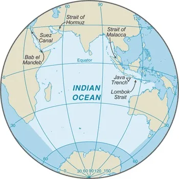
- The Indian Ocean is the third largest of the world's five ocean basins (after the Pacific Ocean and Atlantic Ocean, but larger than the Southern Ocean and Arctic Ocean). Four critically important access waterways are the Suez Canal (Egypt), Bab el Mandeb (Djibouti-Yemen), Strait of Hormuz (Iran-Oman), and Strait of Malacca (Indonesia-Malaysia). The International Hydrographic Organization decided in 2000 to delimit a fifth world ocean basin, the Southern Ocean, which removed the portion of the Indian Ocean south of 60 degrees south latitude.
Geography 13 fields
- Location
- body of water between Africa, the Southern Ocean, Asia, and Australia
- Geographic coordinates
- 20 00 S, 80 00 E
- Area
- total: 70.56 million sq km
- Area - comparative
- almost seven times the size of the US
- Coastline
- 66,526 km
- Climate
- northeast monsoon (December to April), southwest monsoon (June to October); tropical cyclones occur during May/June and October/November in the northern Indian Ocean and January/February in the southern Indian Ocean
- Ocean volume
- ocean volume: 264 million cu kmpercent of World Ocean total volume: 19.8%
- Major ocean currents
- the counterclockwise Indian Ocean Gyre comprised of the southward flowing warm Agulhas and East Madagascar Currents in the west, the eastward flowing South Indian Current in the south, the northward flowing cold West Australian Current in the east, and the westward flowing South Equatorial Current in the north; a distinctive annual reversal of surface currents occurs in the northern Indian Ocean; low atmospheric pressure over southwest Asia from hot, rising, summer air results in the southwest monsoon and southwest-to-northeast winds and clockwise currents, while high pressure over northern Asia from cold, falling, winter air results in the northeast monsoon and northeast-to-southwest winds and counterclockwise currents
- Bathymetry
- continental shelf: the following are examples of features on the continental shelf of the Indian Ocean (see Figure 2):
Exmouth Plateau
Indus Canyon
The Swatch of No Ground/Ganges Canyon (Bay of Bengal)
Sunda Shelfcontinental slope: the following are examples of features on the continental slope of the Indian Ocean (see Figure 2):
Bengal Fan
Indus Fanabyssal plains: the following are examples of features on the abyssal plains of the Indian Ocean (see Figure 2):
Arabian Basin
Crozet Basin
Madagascar Basin
Mid-Indian Basin
Mozambique Basin
Wharton Basinmid-ocean ridge: the following are examples of mid-ocean ridges on the floor of the Indian Ocean (see Figure 2):
Central Indian Ridge
Davie Ridge
Southeast Indian Ridge
Southwest Indian Ridgeundersea terrain features: the following are examples of undersea terrain features on the floor of the Indian Ocean (see Figure 2):
Andaman-Nicobar Ridge
Chagos-Laccadive Ridge
Kerguelen Plateau
Madagascar Plateau
Mascarene Plateau
Mozambique Plateau
Ninetyeast Ridgeocean trenches: the following are examples of ocean trenches on the floor of the Indian Ocean (see Figure 2):
Java/Sunda Trench (deepest point in the Indian Ocean)atolls: the following are examples of atolls in the Indian Ocean (see Figure 2):
Bassas da India
Chagos Archipelago/Diego Garcia
Europa Island
Juan de Nova Island
Lakshadweep Islands
Maldive Islands
Seychelles - Elevation
- highest point: sea levellowest point: Java Trench -7,192 m unnamed deepmean depth: -3,741 mocean zones: the ocean is divided into three zones based on depth and light level; sunlight entering the water may travel about 1,000 m into the oceans under the right conditions, but there is rarely any significant light below 200 m
euphotic zone: the upper 200 m (656 ft) is also called "sunlight" zone; only a small amount of light penetrates beyond this depth
dysphotic zone: between 200 m (656 ft) and 1,000 m (3,280 ft), and also called the twilight zone; the intensity of light rapidly dissipates as depth increases, and photosynthesis is no longer possible
aphotic zone: below 1,000 m (3,280 ft) and also called the midnight zone; sunlight does not penetrate to these depths - Natural resources
- oil and gas fields, fish, shrimp, sand and gravel aggregates, placer deposits, polymetallic nodules
- Natural hazards
- occasional icebergs pose navigational hazard in southern reaches
- Geography - note
- major chokepoints include Bab el Mandeb, Strait of Hormuz, Strait of Malacca, southern access to the Suez Canal, and the Lombok Strait
Environment 3 fields
- Environmental issues
- marine pollution from ocean dumping, improper waste disposal, and oil spills; oil pollution in Arabian Sea, Persian Gulf, and Red Sea; threats to coral reefs; loss of biodiversity; endangered marine species
- Climate
- northeast monsoon (December to April), southwest monsoon (June to October); tropical cyclones occur during May/June and October/November in the northern Indian Ocean and January/February in the southern Indian Ocean
- Marine fisheries
- the Indian Ocean fisheries are the third most important in the world, accounting for 15.5%, or 12,220,000 mt of the global catch in 2020; tuna, small pelagic fish, and shrimp are important species in these regions; the Food and Agriculture Organization delineated two fishing regions in the Indian Ocean: Eastern Indian Ocean region (Region 57) is the most important and the fifth-largest-producing region in the world with 8.4%, or 6,590,000 mt, of the global catch in 2020; the region encompasses the waters north of 55º South latitude and east of 80º East longitude, including the Bay of Bengal and Andaman Sea, with the major producers including India (2,362,481 mt), Indonesia (1,940,558 mt), Burma (1,114,777 mt), Bangladesh (877,837 mt), and Sri Lanka (373,369 mt); the principal catches include shad, skipjack tuna, mackerel, shrimp, and sardinellas Western Indian Ocean region (Region 51) is the world’s sixth-largest-producing region with more than 7.1% or 5,630,000 mt of the global catch in 2020; this region encompasses the waters north of 40º South latitude and west of 80º East longitude, including the western Indian Ocean, Arabian Sea, Persian Gulf, and Red Sea, as well as the waters along the east coast of Africa and Madagascar, the south coast of the Arabian Peninsula, and the west coast of India; major producers include India (2,207,125 mt), Oman (580,048 mt), Pakistan (341,730 mt), and Mozambique (274,791 mt); the principal catches include skipjack and yellowfin tuna, mackerel, sardines, shrimp, and cephalopods
Regional fisheries bodies: Indian Ocean Tuna Commission, Commission for the Conservation of Southern Bluefin Tuna, Regional Commission for Fisheries (Persian Gulf/Gulf of Oman), Southeast Asia Fisheries Development Center, Southwest Indian Ocean Fisheries Commission, South Indian Ocean Fisheries Agreement
Government 1 field
- Country name
- etymology: named for the country of India, which makes up much of its northern border
Indian Ocean