Clipperton Island
Updated
Area
6.00 km²
CIA World Factbook archive
Location
- Region
- North America
- Area
- 6.00 km²
The Factbook archive 25 fields · 6 categories
The complete World Factbook entry for Clipperton Island: 25 fields and 21 sub-entries across 6 categories, kept whole as historical reference. A United States Government work in the public domain, reflecting data as of the final January 2026 edition. Last CIA update: January 8, 2026.
Introduction 1 field
- Background
- This isolated atoll was named for John CLIPPERTON, an English pirate who was rumored to have made it his hideout early in the 18th century. Annexed by France in 1855 and claimed by the US, it was seized by Mexico in 1897. Arbitration eventually awarded the island to France in 1931, which took possession in 1935.
Geography 15 fields
- Location
- Middle America, atoll in the North Pacific Ocean, 1,120 km southwest of Mexico
- Geographic coordinates
- 10 17 N, 109 13 W
- Map references
- Political Map of the World
- Area
- total: 6 sq kmland: 6 sq kmwater: 0 sq km
- Area - comparative
- about 12 times the size of the National Mall in Washington, D.C.
- Land boundaries
- total: 0 km
- Coastline
- 11.1 km
- Maritime claims
- territorial sea: 12 nmexclusive economic zone: 200 nm
- Climate
- tropical; humid, average temperature 20-32 degrees Celsius, wet season (May to October)
- Terrain
- coral atoll
- Elevation
- highest point: Rocher Clipperton 29 mlowest point: Pacific Ocean 0 m
- Natural resources
- fish
- Land use
- agricultural land: 0% (2018 est.)forest: 0% (2018 est.)other: 100% (2018 est.)
- Natural hazards
- subject to tropical storms and hurricanes from May to October
- Geography - note
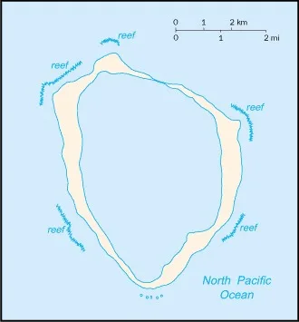
- the atoll reef is approximately 12 km (7.5 mi) in circumference
People and Society 1 field
- Population
- total: uninhabited
Environment 3 fields
- Environmental issues
- no natural resources, guano deposits depleted; stagnant fresh-water lagoon
- Climate
- tropical; humid, average temperature 20-32 degrees Celsius, wet season (May to October)
- Land use
- agricultural land: 0% (2018 est.)forest: 0% (2018 est.)other: 100% (2018 est.)
Government 4 fields
- Country name
- conventional long form: noneconventional short form: Clipperton Islandlocal long form: nonelocal short form: Ile Clippertonformer: sometimes referred to as Ile de la Passion or Atoll Clippertonetymology: named after an 18th-century English pirate who is alleged to have used the island as a base starting in 1705
- Dependency status
- possession of France; administered directly by the Minister of Overseas France
- Legal system
- the laws of France apply
- Flag
- the flag of France is used
Military and Security 1 field
- Military - note
- defense is the responsibility of France
Clipperton Island