Navassa Island
Updated
Area
5.00 km²
CIA World Factbook archive
Location
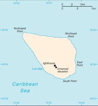
- Region
- Central America and the Caribbean
- Area
- 5.00 km²
The Factbook archive 26 fields · 6 categories
The complete World Factbook entry for Navassa Island: 26 fields and 15 sub-entries across 6 categories, kept whole as historical reference. A United States Government work in the public domain, reflecting data as of the final January 2026 edition. Last CIA update: January 14, 2026.
Introduction 1 field
- Background
- The US claimed uninhabited Navassa Island in 1857 for its guano. Mining took place between 1865 and 1898. The lighthouse, built in 1917, was shut down in 1996, and administration of Navassa Island was transferred from the US Coast Guard to the Department of the Interior, Office of Insular Affairs. A 1998 scientific expedition to the island described it as a "unique preserve of Caribbean biodiversity." The following year it became a National Wildlife Refuge, and annual scientific expeditions have continued.
Geography 15 fields
- Location
- Caribbean, island in the Caribbean Sea, 30 nm west of Tiburon Peninsula of Haiti
- Geographic coordinates
- 18 25 N, 75 02 W
- Map references
- Central America and the Caribbean
- Area
- total: 5 sq kmland: 5.4 sq kmwater: 0 sq km
- Area - comparative
- about nine times the size of the National Mall in Washington, D.C.
- Land boundaries
- total: 0 km
- Coastline
- 8 km
- Maritime claims
- territorial sea: 12 nmexclusive economic zone: 200 nm
- Climate
- marine, tropical
- Terrain
- raised flat to undulating coral and limestone plateau; ringed by vertical white cliffs (9 to 15 m high)
- Elevation
- highest point: 200 m NNW of lighthouse 85 mlowest point: Caribbean Sea 0 m
- Natural resources
- guano (mining discontinued in 1898)
- Land use
- other: 100% (2018 est.)
- Natural hazards
- hurricanes
- Geography - note
- strategic location 160 km south of the US Naval Base at Guantanamo Bay, Cuba; mostly exposed rock with numerous solution holes (limestone sinkholes) but with enough grassland to support goat herds; dense stands of fig trees, scattered cactus
People and Society 1 field
- Population
- total: uninhabited
Environment 3 fields
- Environmental issues
- some coral bleaching
- Climate
- marine, tropical
- Land use
- other: 100% (2018 est.)
Government 5 fields
- Country name
- conventional long form: noneconventional short form: Navassa Islandetymology: the flat island was named "Navaza" by sailors with the Christopher COLUMBUS expedition in 1504; the name derives from the Spanish word nava, meaning "flat land or level ground"
- Dependency status
- unorganized, unincorporated territory of the US; administered by the Fish and Wildlife Service, US Department of the Interior, from the Caribbean Islands National Wildlife Refuge in Boqueron, Puerto Rico; Haiti has claimed the island since the 19th century
- Legal system
- the laws of the US apply
- Diplomatic representation from the US
- embassy: none (territory of the US)
- Flag
- the flag of the US is used
Military and Security 1 field
- Military - note
- defense is the responsibility of the US
Navassa Island