Jan Mayen
Svalbard og Jan Mayen
Updated
Area
377 km²
CIA World Factbook archive
Location
- Region
- Europe
- Subregion
- Northern Europe
- Area
- 377 km²
- Languages
- Norwegian
Reference
- Languages
- Norwegian
- Currency
- krone (NOK)
- Calling code
- +4779
- Internet TLD
- .sj
- ISO codes
- SJ · SJM · 744
The Factbook archive 27 fields · 7 categories
The complete World Factbook entry for Jan Mayen: 27 fields and 18 sub-entries across 7 categories, kept whole as historical reference. A United States Government work in the public domain, reflecting data as of the final December 2025 edition. Last CIA update: December 4, 2025.
Introduction 1 field
- Background
- This desolate, mountainous island in the Arctic Ocean was named after a Dutch whaling captain who indisputably discovered it in 1614 (earlier claims are inconclusive). Visited only occasionally by seal hunters and trappers over the centuries, the island came under Norwegian sovereignty in 1929. The long dormant Beerenberg volcano, the northernmost active volcano on earth, resumed activity in 1970, and the most recent eruption occurred in 1985.
Geography 16 fields
- Location
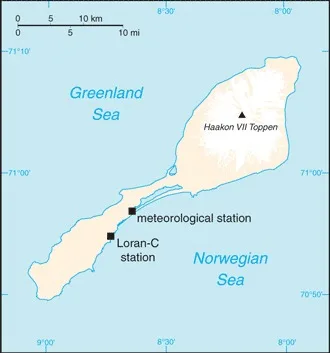
- Northern Europe, island between the Greenland Sea and the Norwegian Sea, northeast of Iceland
- Geographic coordinates
- 71 00 N, 8 00 W
- Map references
- Arctic Region
- Area
- total: 377 sq kmland: 377 sq kmwater: 0 sq km
- Area - comparative
- slightly more than twice the size of Washington, D.C.
- Land boundaries
- total: 0 km
- Coastline
- 124.1 km
- Maritime claims
- territorial sea: 12 nmcontiguous zone: 24 nmexclusive economic zone: 200 nmcontinental shelf: 200-m depth or to the depth of exploitation
- Climate
- arctic maritime with frequent storms and persistent fog
- Terrain
- volcanic island, partly covered by glaciers
- Elevation
- highest point: Haakon VII Toppen on Beerenberg 2,277lowest point: Norwegian/Greenland Seas 0 m
- Natural resources
- none
- Land use
- agricultural land: 0% (2011 est.)other: 100% (2018 est.)
- Irrigated land
- 0 sq km (2022)
- Natural hazards
- dominated by the volcano Beerenberg
volcanism: Beerenberg (2,227 m) is Norway's only active volcano; volcanic activity resumed in 1970; the most recent eruption occurred in 1985 - Geography - note
- barren volcanic spoon-shaped island with some moss and grass flora; island consists of two parts: a larger northeast Nord-Jan (the spoon "bowl") and the smaller Sor-Jan (the "handle"), linked by a 2.5 km-wide isthmus (the "stem") with two large lakes, Sorlaguna (South Lagoon) and Nordlaguna (North Lagoon)
People and Society 1 field
- Population
- total: no permanent inhabitants
Environment 3 fields
- Environmental issues
- pollutants transported from southerly latitudes by winds and ocean currents
- Climate
- arctic maritime with frequent storms and persistent fog
- Land use
- agricultural land: 0% (2011 est.)other: 100% (2018 est.)
Government 4 fields
- Country name
- conventional long form: noneconventional short form: Jan Mayenetymology: named after Dutch Captain Jan Jacobszoon MAY, one of the first explorers to reach the island in 1614
- Dependency status
- territory of Norway; since 1994, administered from Oslo through the county governor (fylkesmann) of Nordland; however, authority has been delegated to a station commander of the Norwegian Defense Communication Service; in 2010, Norway designated the majority of Jan Mayen as a nature reserve
- Legal system
- the laws of Norway apply
- Flag
- the flag of Norway is used
Communications 1 field
- Broadcast media
- a coastal radio station has been remotely operated since 1994
Military and Security 1 field
- Military - note
- defense is the responsibility of Norway
Jan Mayen