South Georgia
South Georgia and the South Sandwich Islands
Updated
Area
3,903 km²
mledoze/countries reference dataset
Capital
King Edward Point
Location
- Capital
- King Edward Point
- Region
- South America
- Area
- 3,903 km²
- Languages
- English
Reference
- Languages
- English
- Currency
- Saint Helena pound (SHP)
- Calling code
- +500
- Internet TLD
- .gs
- Demonym
- South Georgian South Sandwich Islander
- ISO codes
- GS · SGS · 239
The Factbook archive 31 fields · 7 categories
The complete World Factbook entry for South Georgia and South Sandwich Islands: 31 fields and 22 sub-entries across 7 categories, kept whole as historical reference. A United States Government work in the public domain, reflecting data as of the final December 2025 edition. Last CIA update: December 21, 2025.
Introduction 1 field
- Background
- South Georgia and the South Sandwich Islands lie approximately 1,000 km east of the Falkland Islands and have been under British administration since 1908 -- except for a brief period in 1982 when Argentina occupied them. Grytviken, on South Georgia, was a 19th- and early 20th-century whaling station. Famed explorer Ernest SHACKLETON stopped there in 1914 en route to his ill-fated attempt to cross Antarctica on foot. He returned some 20 months later with a few companions in a small boat and arranged a successful rescue for the rest of his crew, which was stranded off the Antarctic Peninsula. He died in 1922 on a subsequent expedition and is buried in Grytviken. Today, the station houses scientists from the British Antarctic Survey. Recognizing the importance of preserving the marine stocks in adjacent waters, the UK extended the exclusive fishing zone in 1993, from 12 nm to 200 nm around each island.
Geography 16 fields
- Location
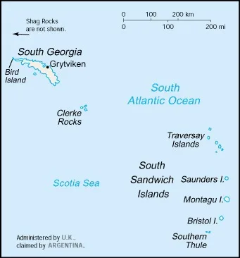
- Southern South America, islands in the South Atlantic Ocean, east of the tip of South America
- Geographic coordinates
- 54 30 S, 37 00 W
- Map references
- Antarctic Region
- Area
- total: 3,903 sq kmland: 3,903 sq kmwater: 0 sq km
- Area - comparative
- slightly larger than Rhode Island
- Land boundaries
- total: 0 km
- Coastline
- NA
- Maritime claims
- territorial sea: 12 nmexclusive fishing zone: 200 nm
- Climate
- variable, with mostly westerly winds throughout the year interspersed with periods of calm; nearly all precipitation falls as snow
- Terrain
- most of the islands are rugged and mountainous rising steeply from the sea; South Georgia is largely barren with steep, glacier-covered mountains; the South Sandwich Islands are of volcanic origin with some active volcanoes
- Elevation
- highest point: Mount Paget (South Georgia) 2,934 mlowest point: Atlantic Ocean 0 m
- Natural resources
- fish
- Land use
- other: 100% (2018 est.)
- Irrigated land
- 0 sq km (2022)
- Natural hazards
- the South Sandwich Islands have prevailing weather conditions that generally make them difficult to approach by ship; they are also subject to active volcanism
- Geography - note
- the north coast of South Georgia has several large bays, which provide good anchorage
People and Society 1 field
- Population
- total: no permanent inhabitants
Environment 3 fields
- Environmental issues
- damage to native wildlife from imported animals
- Climate
- variable, with mostly westerly winds throughout the year interspersed with periods of calm; nearly all precipitation falls as snow
- Land use
- other: 100% (2018 est.)
Government 7 fields
- Country name
- conventional long form: South Georgia and the South Sandwich Islandsconventional short form: South Georgia and South Sandwich Islandsabbreviation: SGSSIetymology: Captain James COOK originally named it "the Isle of Georgia" in 1775 in honor of British King GEORGE III; the word "South" was later added to distinguish these islands from the other Sandwich Islands, now known as the Hawaiian Islands
- Dependency status
- overseas territory of the UK, also claimed by Argentina; administered from the Falkland Islands by a commissioner, who is concurrently governor of the Falkland Islands, representing the British monarch
- Legal system
- the laws of the UK apply
- Diplomatic representation in the US
- none (administered by the UK, claimed by Argentina)
- Diplomatic representation from the US
- none (administered by the UK, claimed by Argentina)
- International organization participation
- UPU
- Flag
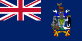
- description: blue with the UK flag in the upper-left quadrant; the islands' coat of arms is centered on the right half of the flag and has a green shield with a golden lion holding a torch; a fur seal is to the left of the shield and a Macaroni penguin to the right; a reindeer appears above the crest, and below the shield on a scroll is the motto LEO TERRAM PROPRIAM PROTEGAT (Let the Lion Protect its Own Land)
meaning: the lion represents the UK and discovery; the seal, penguin, and reindeer are native to the islands
Transportation 2 fields
- Heliports
- 1 (2025)
- Ports
- total ports: 3 (2024)large: 0medium: 0small: 0very small: 3ports with oil terminals: 1key ports: Grytviken, Prince Olav Harbor, Stromness Harbor
Military and Security 1 field
- Military - note
- defense is the responsibility of the UK
Frequently asked
- What is the capital of South Georgia?
- The capital of South Georgia is King Edward Point.
South Georgia