Paracel Islands
Updated
No current statistical feed covers Paracel Islands, so the figures below come from the Factbook archive and do not refresh. Each carries its own observation year.
Population
2,230
2024 · Factbook archive
Area
8.00 km²
CIA World Factbook archive
Location
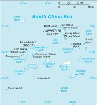
- Region
- East and Southeast Asia
- Area
- 8.00 km²
The Factbook archive 28 fields · 7 categories
The complete World Factbook entry for Paracel Islands: 28 fields and 11 sub-entries across 7 categories, kept whole as historical reference. A United States Government work in the public domain, reflecting data as of the final January 2026 edition. Last CIA update: January 19, 2026.
Introduction 1 field
- Background
- The Paracel Islands are surrounded by productive fishing grounds and potential oil and gas reserves. In 1932, French Indochina annexed the islands and set up a weather station on Pattle Island. China has occupied all the Paracel Islands since 1974, when its troops seized a South Vietnamese garrison occupying the western islands. China has built a military installation on Woody Island with an airfield and artificial harbor, and it has scattered garrisons on some of the other islands. Taiwan and Vietnam also claim the Paracel Islands.
Geography 16 fields
- Location
- Southeastern Asia, group of small islands and reefs in the South China Sea, about one-third of the way from central Vietnam to the northern Philippines
- Geographic coordinates
- 16 30 N, 112 00 E
- Map references
- Southeast Asia
- Area
- total: 8 sq km ca.land: 7.75 sq km ca.water: 0 sq km
- Area - comparative
- land area is about 13 times the size of the National Mall in Washington, D.C.
- Land boundaries
- total: 0 km
- Coastline
- 518 km
- Climate
- tropical
- Terrain
- mostly low and flat
- Elevation
- highest point: unnamed location on Rocky Island 14 mlowest point: South China Sea 0 m
- Natural resources
- none
- Land use
- other: 100% (2018 est.)
- Irrigated land
- 0 sq km (2022)
- Population distribution
- a population of over 1,000 Chinese resides on Woody Island, the largest of the Paracels; there are scattered Chinese garrisons on some other islands
- Natural hazards
- typhoons
- Geography - note
- composed of 130 small coral islands and reefs divided into the northeast Amphitrite Group and the western Crescent Group
People and Society 4 fields
- Population
- total: 2,230 (2024 est.)
- Population growth rate
- 0.75% (2021 est.)
- Net migration rate
- -0.66 migrant(s)/1,000 population (2021 est.)
- Population distribution
- a population of over 1,000 Chinese resides on Woody Island, the largest of the Paracels; there are scattered Chinese garrisons on some other islands
Environment 3 fields
- Environmental issues
- harm to reef systems from China's use of dredged sand and coral to build artificial islands; damage to ecosystem from human activities, including military operations, infrastructure construction, and tourism
- Climate
- tropical
- Land use
- other: 100% (2018 est.)
Government 1 field
- Country name
- conventional long form: noneconventional short form: Paracel Islands
Transportation 2 fields
- Airports
- 2 (2025)
- Heliports
- 7 (2025)
Military and Security 1 field
- Military - note
- occupied by China, which is assessed to maintain 20 outposts or bases in the Paracels (Antelope, Bombay, and North reefs; Drummond, Duncan, Lincoln, Middle, Money, North, Pattle, Quanfu, Robert, South, Tree, Triton, Woody, and Yagong islands; South Sand and West Sand; Observation Bank); Woody Island is the main military base and includes an airstrip with aircraft hangers, naval facilities, surveillance radars, and defenses such as surface-to-air missiles and anti-ship cruise missiles (2025)
Paracel Islands