Svalbard
Svalbard og Jan Mayen
Updated
No current statistical feed covers Svalbard, so the figures below come from the Factbook archive and do not refresh. Each carries its own observation year.
Population
2,556
2025 · Factbook archive
Area
62,045 km²
CIA World Factbook archive
Location
- Region
- Europe
- Subregion
- Northern Europe
- Area
- 62,045 km²
- Languages
- Norwegian
Reference
- Languages
- Norwegian
- Currency
- krone (NOK)
- Calling code
- +4779
- Internet TLD
- .sj
- ISO codes
- SJ · SJM · 744
The Factbook archive 46 fields · 9 categories
The complete World Factbook entry for Svalbard: 46 fields and 47 sub-entries across 9 categories, kept whole as historical reference. A United States Government work in the public domain, reflecting data as of the final December 2025 edition. Last CIA update: December 22, 2025.
Introduction 1 field
- Background
- Norse explorers may have first discovered the Svalbard archipelago in the 12th century. The islands served as an international whaling base during the 17th and 18th centuries. Norway's sovereignty was internationally recognized by treaty in 1920, and five years later Norway officially took over the territory. Coal mining started in the 20th century, and a Norwegian company and a Russian company are still in operation today. Travel between the settlements is accomplished with snowmobiles, aircraft, and boats.
Geography 16 fields
- Location
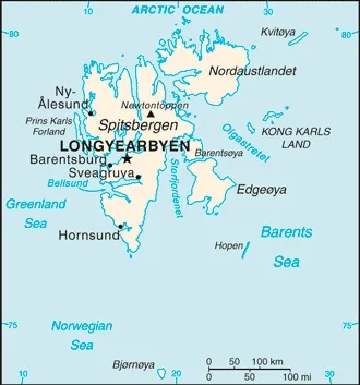
- Northern Europe, islands between the Arctic Ocean, Barents Sea, Greenland Sea, and Norwegian Sea, north of Norway
- Geographic coordinates
- 78 00 N, 20 00 E
- Map references
- Arctic Region
- Area
- total: 62,045 sq kmland: 62,045 sq kmwater: 0 sq km
- Area - comparative
- slightly smaller than West Virginia
- Land boundaries
- total: 0 km
- Coastline
- 3,587 km
- Maritime claims
- territorial sea: 12 nmcontiguous zone: 24 nmcontinental shelf: extends to depth of exploitationexclusive fishing zone: 200 nm
- Climate
- arctic, tempered by warm North Atlantic Current; cool summers, cold winters; North Atlantic Current flows along west and north coasts of Spitsbergen, keeping water open and navigable most of the year
- Terrain
- rugged mountains; much of the upland areas are ice covered; west coast clear of ice about half the year; fjords along west and north coasts
- Elevation
- highest point: Newtontoppen 1,717 mlowest point: Arctic Ocean 0 m
- Natural resources
- coal, iron ore, copper, zinc, phosphate, wildlife, fish
- Land use
- agricultural land: 0% (2018 est.)other: 100% (2018 est.)
- Population distribution
- the small population is primarily concentrated on the island of Spitsbergen in a handful of settlements on the south side of the Isfjorden, with Longyearbyen being the largest
- Natural hazards
- ice floes often block the entrance to Bellsund (a transit point for coal export) on the west coast and occasionally make parts of the northeastern coast inaccessible to maritime traffic
- Geography - note
- northernmost part of the Kingdom of Norway; consists of nine main islands; glaciers and snowfields cover 60% of the total area
People and Society 6 fields
- Population
- total: 2,556 (2025 est.)male: 1,353female: 1,203
- Ethnic groups
- Norwegian 61.1%, foreign population 38.9% (consists primarily of Russians, Thais, Swedes, Filipinos, and Ukrainians) (2021 est.)
note: foreigners account for almost one third of the population of the Norwegian settlements, Longyearbyen and Ny-Alesund (where the majority of Svalbard's resident population lives), as of mid-2021 - Languages
- Languages: Norwegian, Russianmajor-language sample(s):
Verdens Faktabok, den essensielle kilden for grunnleggende informasjon. (Norwegian)
The World Factbook, the indispensable source for basic information. - Population growth rate
- -0.03% (2019 est.)
- Net migration rate
- -5.57 migrant(s)/1,000 population (2021 est.)
- Population distribution
- the small population is primarily concentrated on the island of Spitsbergen in a handful of settlements on the south side of the Isfjorden, with Longyearbyen being the largest
Environment 2 fields
- Climate
- arctic, tempered by warm North Atlantic Current; cool summers, cold winters; North Atlantic Current flows along west and north coasts of Spitsbergen, keeping water open and navigable most of the year
- Land use
- agricultural land: 0% (2018 est.)other: 100% (2018 est.)
Government 14 fields
- Country name
- conventional long form: noneconventional short form: Svalbard (sometimes referred to as Spitsbergen, the largest island in the archipelago)etymology: the archipelago was traditionally known as Spitsbergen, a Dutch name meaning "jagged peaks," but Norway renamed it Svalbard in the 1920s when it assumed sovereignty of the islands, from the Norwegian sval (cold) and bard (shore); the Norwegian name may have been used during the Norse era for other locations
- Government type
- non-self-governing territory of Norway
- Dependency status
- territory of Norway; administered by the Polar Department of the Ministry of Justice, through a governor (sysselmann) residing in Longyearbyen, Spitsbergen; by treaty (9 February 1920), sovereignty was awarded to Norway
- Capital
- name: Longyearbyengeographic coordinates: 78 13 N, 15 38 Etime difference: UTC+1 (6 hours ahead of Washington, DC, during Standard Time)daylight saving time: +1hr, begins last Sunday in March; ends last Sunday in Octoberetymology: the name in Norwegian means Longyear Town; the site was established by and named after John Munro LONGYEAR, whose Arctic Coal Company began mining operations there in 1906
- Legal system
- laws of Norway that explicitly apply to Svalbard, including the Svalbard Act, the Svalbard Environmental Protection Act, and certain regulations; the Spitsbergen Treaty and the Svalbard Treaty grant certain rights to citizens and corporations of signatory nations
- Citizenship
- see Norway
- Executive branch
- chief of state: King HARALD V of Norway (since 17 January 1991)head of government: Governor Lars FAUSE (since 24 June 2021)election/appointment process: none; the monarchy is hereditary; governor and assistant governor responsible to the Polar Department of the Ministry of Justice
- Legislative branch
note: the Council acts much like a Norwegian municipality, with responsibility for infrastructure and utilities (including power, land-use and community planning, education, and child welfare); however, the state provides healthcare services- Judicial branch
- highest court(s): Svalbard is subordinate to Norway's Nord-Troms District Court and Halogaland Court of Appeal, both located in Tromso
- Political parties
- Conservative
Labor
Liberal
Progress
Socialist Left - International organization participation
- none
- Independence
- none (territory of Norway)
- Flag
- the flag of Norway is used
- National anthem(s)
- title: "Ja, vi elsker dette landet" (Yes, We Love This Country)lyrics/music: Bjornstjerne BJORNSON/Rikard NORDRAAKhistory: official anthem, as a Norwegian territory
Economy 2 fields
- Economic overview
- high-income Norwegian island economy; major coal mining, tourism, and research sectors; recently established northernmost brewery; key whaling and fishing base; home to the Global Seed Vault
- Exchange rates
- Currency: Norwegian kroner (NOK) per US dollar -Exchange rates 2024: 10.746 (2024 est.)Exchange rates 2023: 10.563 (2023 est.)Exchange rates 2022: 9.614 (2022 est.)Exchange rates 2021: 8.59 (2021 est.)Exchange rates 2020: 9.416 (2020 est.)
Communications 2 fields
- Broadcast media
- Norwegian Broadcasting Corporation (NRK) provides TV transmission to Svalbard via satellite; access to 3 NRK radio stations and 2 TV stations
- Internet country code
- .sj
Transportation 1 field
- Ports
- total ports: 3 (2024)large: 0medium: 0small: 0very small: 3ports with oil terminals: 0key ports: Barentsburg, Longyearbyen, Ny Alesund
Military and Security 2 fields
- Military and security forces
- no regular military forces
- Military - note
- Svalbard is a territory of Norway, demilitarized by treaty on 9 February 1920; Norwegian military activity is limited to fisheries surveillance by the Norwegian Coast Guard (2025)
Svalbard